High Resolution Digital Elevation Models (DEMs) from LiDAR.
Professional elevation models at any scale—from a single construction site to the entire US. We deliver survey grade DEMs from precise LiDAR datasets built to your specification.
DEM Product Types
| Product | Description | What It Shows | Key Applications |
|---|---|---|---|
| DSM (Digital Surface Model) | Complete surface capture including all features | Top of buildings, tree canopy, infrastructure, and ground | 3D city modeling, telecommunications planning, solar analysis, Line-of-Sight (LoS) |
| DTM (Digital Terrain Model) | Bare earth elevation with all surface features removed | Ground surface only - no buildings or vegetation | Flood modeling, earthwork calculations, watershed analysis |
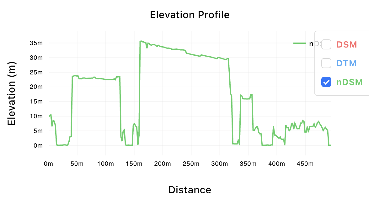
| nDSM (Normalized DSM) | Height above ground for all features (DSM minus DTM) | Relative heights - buildings, trees, structures above ground | Building extraction, vegetation management, change detection |
Seamless, Survey-Grade Output

Seamless Multi-Source Fusion
Multiple LiDAR datasets are intelligently merged into a single, continuous elevation model with no visible boundaries or processing artifacts. Our fusion algorithms ensure centimeter-level vertical accuracy is maintained across dataset boundaries, delivering professional-grade output ready for engineering analysis, volumetric calculations, and regulatory compliance.
Professional-Grade Elevation Products
Our nDSM products deliver precise height measurements critical for infrastructure planning, volumetric analysis, and change detection. Every pixel represents accurate elevation data suitable for engineering calculations, regulatory submissions, and operational decision-making. From telecommunications tower siting to flood risk assessment, these are analysis-ready products that meet professional standards.
Intelligent Source Selection & Fusion
With thousands of overlapping LiDAR datasets available, selecting the optimal sources for your area of interest is critical. Our automated pipeline intelligently evaluates and combines the best available data to deliver a seamless, high-quality product.
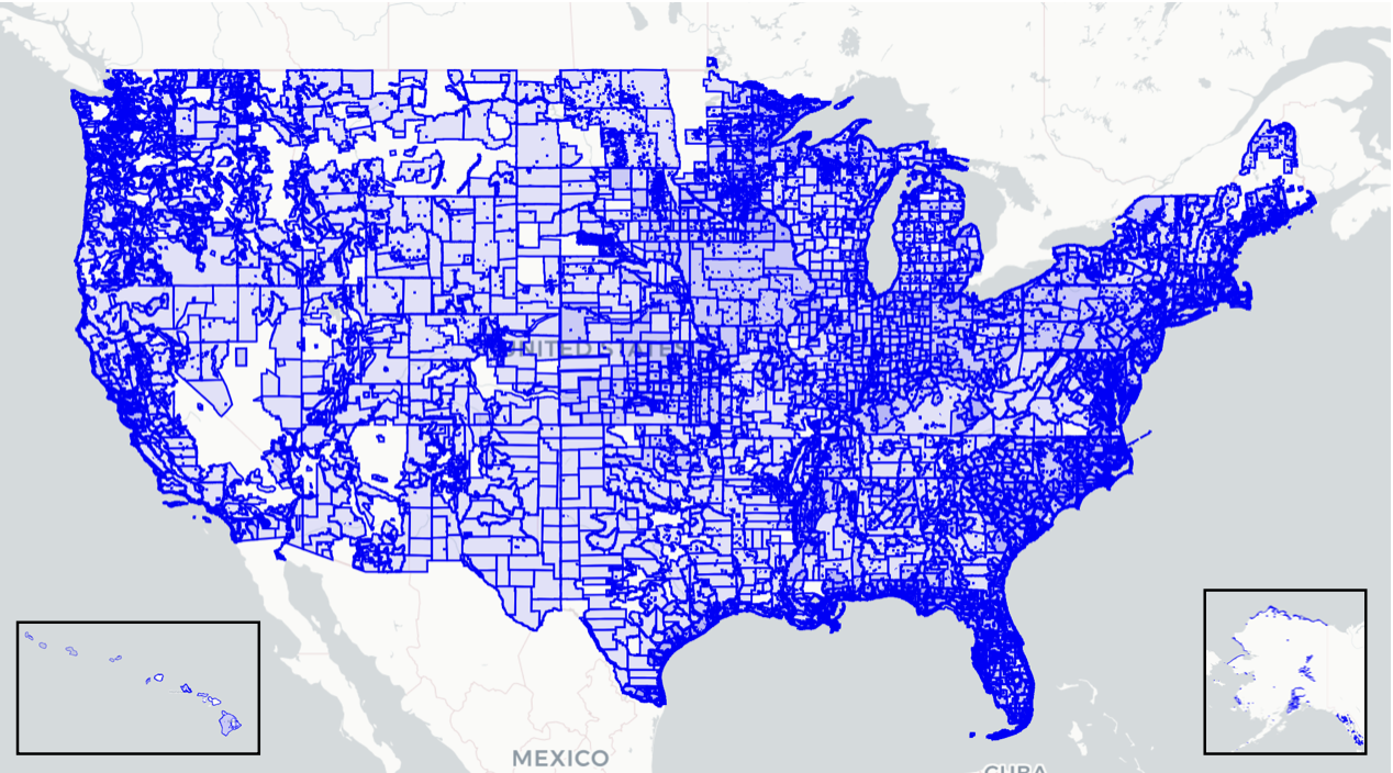
5,000+ LiDAR datasets indexed nationwide
Source Indexing
- •Precise boundary mapping for all 5,000+ LiDAR projects
- •Metadata cataloging including projection, datum, and collection date
- •Point density and classification quality metrics
- •Temporal coverage from 2000 to present
Optimal Selection Algorithm
- •Prioritizes newest and highest density sources for your AOI
- •Evaluates overlap areas for quality and consistency
- •Accounts for project-specific requirements (urban vs rural)
- •Works seamlessly from single parcels to state-wide coverage
Seamless Fusion
- •Advanced edge-matching at source boundaries
- •Consistent vertical datum alignment across sources
- •No visible seams or artifacts in final product
- •Delivered with "cut file" showing source provenance for each area
Standard Product Specifications
| Specification | Standard Delivery | Notes |
|---|---|---|
| DEM Types | DSM, DTM, nDSM package | Can be ordered individually, but nDSM requires processing of both DSM and DTM |
| Coordinate Reference System (CRS) | UTM Zone, NAD83 | Support for State Plane or any Geographic or Projected Coordinate system. |
| Vertical Datum | NAVD88 meters (ft optional), Geoid-based | Support for Ellipsoid height, or specific geoid alignment (i.e. GEOID12B, GEOID18) |
| Grid Resolution | 30cm-1m grid-aligned | 30-50cm (based on source density for a given AOI) |
| Quality Control | Advanced noise removal | Classification based & custom k-mean filtering |
| Coverage Gaps | DTM infilled with USGS 10m | Provides seamless DTM coverage where there is no visible terrain; such as under buildings. |
| File Format | GeoTIFF (BigTiff, COG) | Support most output formats. |
Technical Differentiation
LiDAR vs Satellite Technology
LiDAR technology penetrates vegetation canopy to capture true bare earth elevations. This fundamental advantage enables accurate flood modeling, infrastructure planning, and terrain analysis in areas where satellite-based products simply are not fit for the task.
| Provider | Technology | Vertical Accuracy | Resolution |
|---|---|---|---|
| LiDAR Atlas | LiDAR | Sub-meter | 30cm |
| Airbus WorldDEM | Satellite | 2m RMSE | 12m |
| Maxar | Satellite | 2-3m RMSE | 2m |
| AW3D | Satellite | 5m RMSE | 2.5m |
Technical Specifications Available
Request detailed technical specifications, coverage maps, and accuracy reports for your area of interest.